About
Budapest GeoSummit 2025 conference
Dear Colleagues, Welcome to the GeoSummit 2025 conference website!
We are pleased to invite you to participate in the GeoSummit 2025, an international gathering focused on the latest advancements in geoscience, geospatial technologies, and related disciplines. The conference will be held in Budapest, Hungary, from 12 to 13 May 2025 (Monday to Tuesday).
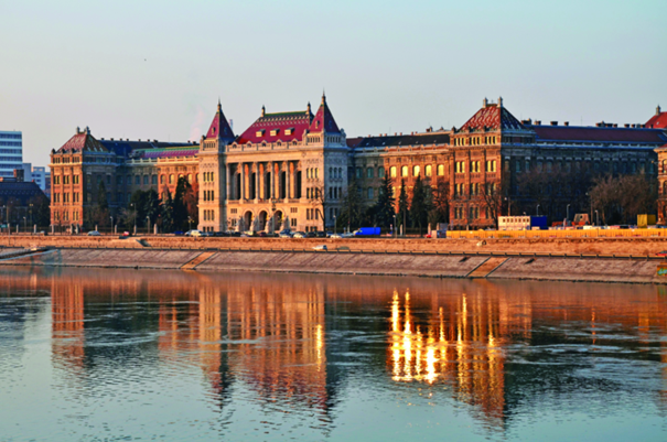
Budapest, the vibrant capital of Hungary, is renowned for its historical landmarks, monumental architecture, thermal baths, dynamic nightlife, scenic parks, and exceptional culinary offerings. As a major city in the heart of Europe and a member of the European Union, Budapest provides an enriching atmosphere for visitors from all over the globe. Its well-developed public transportation system, extensive bicycle paths, and electric scooter availability make navigating the city easy and enjoyable.
The conference will be hosted at the Budapest University of Technology and Economics (BME), Hungary's largest and most prestigious technical university, with the event held primarily at the Faculty of Civil Engineering. The BME campus, situated on the right bank of the Danube River, offers a spectacular view of the UNESCO World Heritage-listed Danube, and its proximity to the city center means that shops, restaurants, cafes, and many accommodations are just a short walk away.
GeoSummit 2025 is an excellent opportunity for geoscientists, engineers, managers, and professionals from around the world to come together, share insights, discuss emerging trends, and foster collaborative initiatives in the field of geosciences and geospatial technologies. The conference also provides a unique opportunity to expand professional networks, exchange knowledge, and build new partnerships.
If you have any questions, please do not hesitate to contact a member of the Organising Committee by email: geosummit2025@emk.bme.hu

Download the shareable GeoSummit 2025 conference flyer: here
Conference Programme


Download the shareable GeoSummit 2025 detailed programme: here
Conference summary
Conference summary
Keynote presentations:
- Arpad Barsi keynote presentation
- Christian Heipke keynote presentation
- Csaba Benedek keynote presentation
- Daniela Poli keynote presentation
- Dorota Iwaszczuk keynote presentation
- Fabio Remondino keynote presentation
- Monika sester keynote presentation
- Nicolas Paparoditis keynote presentation
- Norbert Haala keynote presentation
- Peter J.G. Teunissen keynote presentation
- Szabolcs Rozsa keynote presentation
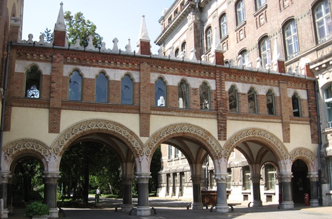
Venue
GeoSummit 2025 takes place in Budapest, capital of Hungary at the Faculty of Civil Engineering, Budapest University of Technology and Economics, which is the largest institute providing civil engineering university education in Hungary. Keeping with the tradition of excellence, today's graduates exhibit a high quality of engineering craftsmanship and skills
More information: xplore.bme.hu
Accomodation
You can choose your accommodation from variety of facilities in the neighborhood of the symposium venue. We recommend you to use some of travel metasearch engines (e.g. booking.com, hotels.com, trivago, airbnb etc.). Please keep in mind that the accommodation capacities are limited. We would like to encourage you to book your room/apartment as soon as possible

Recommended hotels
Ibis Budapest Centrum Hotel
https://ibis-budapest-centrum.h-rez.com/
Mercure Hotel Castle Hill
https://ibis-budapest-centrum.h-rez.com/
Mercure Hotel Korona
https://ibis-budapest-centrum.h-rez.com/
Ibis Styles Hotel
https://ibis-budapest-centrum.h-rez.com/
Registration
Local Organizing Committee
| Name | Institution | Country |
|---|---|---|
| Tamás Lovas Chairman |
Budapest University of Technology and Economics | Hungary |
| Charles Toth Vice Chairman |
The Ohio State University | USA |
| Kristóf Kapitány | Budapest University of Technology and Economics | Hungary |
| Zsofia Kugler | Budapest University of Technology and Economics | Hungary |
| Janos Mate Logo | Budapest University of Technology and Economics | Hungary |
| David Sik | Budapest University of Technology and Economics | Hungary |
Keynote & Invited Speakers
 Christian Heipke, Institute of Photogrammetry and GeoInformation, Leibniz University Hannover, Germany
Short Bio:
Christian Heipke is a professor of photogrammetry and remote sensing at Leibniz Universität Hannover, where he currently leads a group of about 25 researchers. His professional interests comprise all aspects of photogrammetry, remote sensing, image understanding and their connection to computer vision and GIS. His has authored or co-authored close to 500 scientific papers, more than 100 of which appeared in peer-reviewed international journals. He also supervised more than 40 PhD candidates as main supervisor.
From 2011-2014 he was chair of the German Geodetic Commission (DGK), since 2012 he serves on the Council of the International Society for Photogrammetry and Remote Sensing (ISPRS), from 2016-2022 as President.
He is a member of different learnt societies. His work has been recognised various times, he is, e.g., the recipient of the 2012 ISPRS Fred Doyle Award and the 2013 ASPRS Photogrammetric (Fairchild) Award. In 2023 he was made an Honorary Fellow of the Indian Society of Remote Sensing. In the same year he received an honorary doctorate from the University of Stuttgart in Germany.
AI in Photogrammetry and Remote Sensing
Photogrammetry is a technique for image capture and analysis, as well as 3D reconstruction from images, which has its roots in the 19th century. When space images became available, remote sensing was added to the name of the discipline. Recently, also the term computer vision has been extensively used to describe essentially the same methods, techniques and algorithms, which are increasingly based on recent developments in artificial intelligence, machine learning and deep learning.
After a short introduction of photogrammetry, remote sensing and computer vision, an overview of current sensor systems for geospatial data acquisition, as well as automatic data processing procedures is given, both for geometric and for sematic results. We then discuss current research questions and new applications, where a focus is laid on methods borrowed from deep learning: Digital image matching, the derivation of image orientation and 3D surfaces as well as automated image analysis are dealt with, whether for the purpose of updating topographic or thematic databases, for documentation and planning in the field of sustainable development, as part of driver assistance systems, for the navigation of robots of all kinds, or as a tool for reducing CO2 emission in concrete production.
It thus becomes clear that images and image sequences contain essential information that is typically used together with other spatial and non-spatial data to solve tasks fascinating in terms of research as well as relevant for today's society.
 Uwe Sörgel, Institute for Photogrammetry and Geoinformatics, Faculty of Aerospace Engineering and Geodesy, University of Stuttgart, Germany
Short Bio:
Uwe Soergel chairs the Institute for Photogrammetry and Geoinformatics at University of Stuttgart, Germany. He received the Diplomingenieur (M.Sc.) degree in electrical engineering from University of Erlangen-Nuremberg, Germany, in 1997. From fall 1997 to the end of 2005, he was a research associate with the Institute for Optronics and Pattern Recognition (FOM) located in Ettlingen (Germany), which was part of FGAN, a former German research establishment focusing on defense-related studies. At that time, he dealt mainly with pattern recognition of man-made objects from remote sensing imagery, with emphasis on SAR data. In parallel, he earned a PhD in electrical engineering and computer science from the Leibniz Universität Hannover, Germany, in 2003.
Prior to his current position starting from 2006 he was first Assistant Professor and later Associate Professor for Radar Remote Sensing and for Radar Remote Sensing and Active Systems, respectively, at Leibniz Universität Hannover. From October 2013 until end of March 2016 he was Full Professor for Remote Sensing and Image Analysis at Technische Universität Darmstadt, Germany.
Uwe's main research interests are remote sensing, automated image analysis, and pattern recognition. The focus areas of his scientific work comprise analysis of SAR and airborne laserscanning data, SAR Interferometry, Crowd Sourcing, and fusion of different kinds of remote sensing image data. He has authored and co-authored ca. 200 publications (about 70 peer-review) and three book chapters; he edited one book and was (co-)editor of the proceedings of four.
Paid Crowdsourcing in Remote Sensing: Applications and Quality Control
Today we are experiencing an enormous increase in the collection of earth observation data, only a fraction of which can be evaluated by human experts alone. This means that the analysis relies more and more on automatic processes, today of course primarily from the domain of deep learning. Such methods however require large amounts of annotated training data, for example for the task of automatic land cover classification. One way to provide sufficient data of such kind is through paid crowdsourcing, which is carried out by laypeople who receive a small amount of money for each service provided.
The topic is discussed using two examples of different data modalities. On the one hand, the task of digitizing tree outlines in aerial images was chosen because a particularly large number of different results provided by individual crowd workers are expected here that need to be evaluated. The second study deals with 3D laser scanning point clouds, a data modality that is particularly difficult for non-experts to handle. Of course, strict quality control is necessary. Furthermore, the data must be prepared and visualized in such a way that the workers, who are non-experts, can carry out the task well and with high motivation.
 Norbert Haala, Institute for Photogrammetry and Geoinformatics, University of Stuttgart, Germany
Short Bio:
Norbert Haala is Professor at the Institute for Photogrammetry and Geoinformatics, University of Stuttgart, where he is responsible for research and teaching in photogrammetric computer vision and image processing. Currently, Prof. Haala chairs the working group WG II/2 Point Cloud Generation and Processing within the International Society for Photogrammetry and Remote Sensing (ISPRS) and the working group Sensors and Platforms of the German Society for Photogrammetry, Remote Sensing and Geoinformation (Deutsche Gesellschaft für Photogrammetrie, Fernerkundung und Geoinformation, DGPF). He is also organizer of the biannual EuroSDR Workshop on Point Cloud Processing. Norbert Haala is winner of the Carl Pulfrich Award in 2013 honoring his impacts to further develop photogrammetric restitutions, in particular in the areas of 3D City Modelling, Dense Image Matching and the use of Remotely Piloted Aircraft Systems (RPAS). In addition to the evaluation and automatic interpretation of LiDAR data, both from airborne and terrestrial platforms, his main interests cover automatic approaches for SLAM-based generation of high-quality 3D data.
SLAM-based Mapping of Complex Indoor Environments
Dense 3D scene reconstruction from imagery remains a core challenge in computer vision, robotics, and photogrammetry. Recent breakthroughs in deep learning, including 3D Gaussian Splatting, have significantly advanced both the performance and visual quality of such reconstructions. The presentation discusses these advancements on example of a project aiming at the 3D mapping of complex, large-scale indoor environments with the long-term goal of autonomous indoor construction for new or preexisting buildings. Data collection applies a 6-wheeled robotic platform, equipped with a camera head with four ZED X RGB-D cameras and a multi-channel LiDAR. The presentation first discusses state-of-the-art SLAM-based 3D data collection compared to standard photogrammetric mapping approaches. The second part demonstrates the viability of the captured 3D representations for localization purposes. The reference map is generated by visual SLAM, which also provides the foundation of 3D Gaussian Splatting. We demonstrate that enriching reference data with images rendered from these 3D Gaussian Splats at randomly sampled poses significantly improves the performance of current visual localization methods as a prerequisite for task planning of the construction robots.
 Monika Sester, Institute for Cartography and Geoinformatics, Leibniz University Hannover, Germany
Short Bio:
Dr. Monika Sester has a background in Geodesy and is Professor for Cartography and Geoinformatics at Leibniz University Hannover, Germany. Her research interest lies in the automation of spatial data processing - mainly using optimization and Machine Learning techniques. Methods are developed for the analysis and interpretation of vector data, trajectories and LiDAR data, as well as social media data for applications in mobility, autonomous driving, environmental risk analysis and sustainable cities.
Sustainable Urban Mobility
Sustainability is often pursued through the principles of Improve, Shift, Avoid: Improve means reduction of resources by using more energy efficient technologies; Reduce energy or land consumption by using more energy-efficient / environmentally friendly technologies; Shift refers to seeking alternative travel modes; Avoid means to replace travels with activities, which can be reached, e.g. by active mobility.
These principles have many aspects and can be supported by spatial data analysis and processing. In the presentation methods and applications will be presented towards sustainable mobility. Work at the Institute of Cartography and Geoinformatics in Hannover span from determination of dynamic maps for future autonomous cars, also including predictions about behaviour of traffic participants, to ways of communicating navigation information to users, also targeting at sustainable behaviour.
 Fabio Remondino, Bruno Kessler Foundation (FBK) in Trento, Italy
Short Bio:
Fabio Remondino is the head of the 3D Optical Metrology research unit at FBK - Bruno Kessler Foundation, a public research center in Trento, Italy. He received a PhD in Photogrammetry from ETH Zurich in 2006. His main research interests are in the field of reality-based 3D surveying and modeling, sensor and data fusion and 3D data classification. He is the author of more than 200 articles in journals and conferences. He is involved in knowledge and technology transfer, having organized more than 30 conferences, 20 summer schools and 5 tutorials. Fabio served as Vice-President of EuroSDR (2017-2023), President of ISPRS Technical Commission V and II (2012-2021) as well as vice-President of CIPA Heritage Documentation (2015 to 2019).
Giving a Meaning to 3D Point Clouds
3D point clouds are more and more available, being created with passive or active sensors, mounted on ground or airborne platforms. Operative approaches for point cloud classification rely on hand-crafted feature extraction rules and a variety of machine learning approaches. With the advancements of deep learning techniques, the use of neural networks has gained traction, including the combination of logic rules, with some successful operative methods. The talk will present actual methods for point cloud semantic enrichment, including recent benchmarks, operative approaches and still existing challenges. Examples from forestry, urban and heritage scenarios will be presented.
 Nicolas Paparoditis, National Institute of Geographic and Forest Information (IGN France)
Short Bio:
Nicolas Paparoditis is currently Deputy General Director of IGN-France. He is a senior research Professor and technologist. He was previously Director of Research and Higher Education at IGN-France, head of the Ecole Nationale des Sciences Géographiques, the French engineering school of Geoinformation, and Vice-President of University Gustave Eiffel. Before that he chaired the MATIS remote sensing and 3D image processing laboratory of IGN. He started his career in 1992 in the Industry working for Aerospatiale on 3D mapping from VHR satellite images. He has also been the Officer in charge of the programme "Digital Models/Twins" at ANR, the French National Research Agency, in the early 2010's.
Nicolas Paparoditis is an international expert of remote sensing, photogrammetric computer vision, and computer graphics for 3D geodata collection systems and their application to smart cities and more globally to public policies. He has supervised 20 Phds and has published over hundred and fifty papers in the field of remote sensing, photogrammetry, and spatial information sciences mostly published in ISPRS journals and proceedings. He has also led several large national research and innovation projects around the development of technologies for 3D geodata collection, geovisualisation, digital globes and digital twins.
Nicolas Paparoditis has been involved in ISPRS since 2000. He has been Chair of the ISPRS former Commission III (2008-2012), the XXIV ISPRS congress director (2016-2022). He is currently Vice-President of ISPRS (2022-2026) and Vice-President of EuroGeographics.
National Mapping Programs
This presentation will explore the current trends for a National Mapping Agency, with a particular emphasis on innovation. We will first highlight the growing need for higher-frequency Very High Resolution (VHR) data to monitor the rapid changes occurring across our countries and landscapes, driven by climate change and human activity. Following this, we will introduce the evolution of data collection programs at IGN, which are increasingly adopting a multi-source approach.
Next, we will present an innovative and agile processing workflow designed to produce VHR Land Use/Land Cover (LULC) data at a ground resolution of 20 cm. By leveraging deep learning and large-scale learning samples, this workflow enables the monitoring of landscape evolution every two years to assess compliance with France's "Zero Net Artificialisation" law.
We will then demonstrate how LULC data, combined with point clouds and watertight meshes computed across France, will form the core data of the French Digital Twin. This initiative aims to create a platform that serves as both a hub for scientific research and a marketplace and assembles and integrates geodata, geovisualization tools, simulation algorithms, and computing capacities. The goal of this National scale twin is to facilitate complex decision-making and support the design, monitoring, and evaluation of public policies, particularly in the field of ecological transition.
Beyond the Digital Twin initiative, this presentation will also highlight the importance of building GeoInformation Technological Commons. By doing so, we could/can better structure our community's technological developments to collectively address the significant challenges that lie ahead.
 Daniela Poli, AVT Airborne Sensing Italia srl
Short Bio:
Daniela Poli is expert in photogrammetry, remote sensing, and geospatial data analysis, with a particular focus on applying advanced technologies in aerial mapping. She currently serves as the General Manager of AVT Airborne Sensing Italia, based in Trento, Italy, which is part of the AVT Group. Daniela holds a degree in Environmental Engineering from Politecnico di Milano (Italy) and a Ph.D. in Photogrammetry and Remote Sensing from the Swiss Federal Institute of Technology in Zurich (ETH Zurich, Switzerland).
Throughout her career, Daniela has worked with both academic and research institutions, including ETH Zurich and the Joint Research Center of the European Commission in Ispra, Italy, as well as private companies like CyberCity AG in Zurich. She has applied her knowledge to various industries, including mapping, environmental monitoring, and geospatial data analysis. In addition to her technical expertise, Daniela is deeply involved in the scientific community. She was an active member of the International Society for Photogrammetry and Remote Sensing (ISPRS) for several years and currently serves as a board member of the Italian Society of Photogrammetry and Surveying (SIFET). Daniela's contributions continue to shape the future of geospatial technologies, further establishing her as a leading figure in the field.
Airborne Mapping: Overview
This presentation will provide an overview of the latest advancements in aerial photogrammetry from the perspective of an aerial surveying company, highlighting key challenges and industry trends. AVT Airborne Sensing, based in Europe, operates a fleet of five aircraft equipped with nadir and oblique photogrammetric cameras, LiDAR, thermal, and hyperspectral sensors, and has extensive and multi-decennial experience with projects at local, regional, and national levels. Notable trends at the sensor level are the move towards CMOS sensors and Bayer patterns stitching approaches or the increasing use of hybrid systems which integrate LiDAR and oblique image acquisition into a single system. Hybrid approaches also include mounting sensors like LiDAR, photogrammetric, thermal or hyperspectral cameras in two separate aircraft hatches, to acquire data simultaneously.
The talk will explore these trends and systems for aerial mapping purposes, alongside with challenges in terms of operational constraints. Additionally, it will address the challenges of working with oblique aerial images, for example the limitations of available software solutions, and the in-house Measuree tool for 3D measurements in oblique blocks. Finally, the impact of climate change and the need for optimized acquisition times will be addressed.
 Dorota Iwaszczuk, Remote Sensing and Image Analysis, Department of Civil and Environmental Engineering Sciences Technical University of Darmstadt, Germany
Short Bio:
Dorota Iwaszczuk is a researcher in remote sensing, photogrammetry and image analysis. Since 2019 she is a professor at the Technical University of Darmstadt, specializing in sensor data fusion, mobile mapping, semantic segmentation and 3D scene analysis. She earned her Ph.D. in photogrammetry and remote sensing from the Technical University of Munich in 2015, where she also worked as a postdoctoral researcher until 2018. She was a visiting scholar at Ohio State University, USA, and Curtin University, Perth, Australia. She holds a Master's degree in geodesy and cartography from the AGH University of Krakow, Poland.
Since 2024, she serves as the vice president of the German Society for Photogrammetry, Remote Sensing, and Geoinformation (DGPF). She has been an officer of the International Society for Photogrammetry and Remote Sensing (ISPRS) since 2012 and is currently co-chair of ISPRS ICWG I/IV "Robotics for Mapping and Machine Intelligence". Additionally, she is a member of the editorial advisory board of the ISPRS Journal of Photogrammetry and Remote Sensing. She is involved in organization of scientific events and belong to main organizers of the workshop GEOBENCH "Evaluation and Benchmarking of Sensor, System and Geospatial Data in Photogrammetry and Remote Sensing".
AI-based Extraction of Urban Objects from Images and 3D Point Clouds
The classification and extraction of urban objects from point clouds and imagery are crucial for advancing urban planning and development. The rapid development of artificial intelligence (AI), particularly deep learning, has brought meaningful advancements in geospatial data processing, helping to better analyze urban scenes. This presentation highlights the application of AI for the analysis and classification of urban objects, starting with outdoor scenes featuring complex building structures and urban vegetation, then transitioning to indoor environments. A methodological focus is placed on incorporating domain knowledge to refine deep-learning-based semantic segmentation by utilizing techniques such as conditional random fields. The increasing availability of foundation models also opens new possibilities for urban mapping tasks. In this talk, various applications of the Segment Anything Model (SAM) in scene interpretation tasks will be discussed. For instance, SAM will be compared with AI-aided polygonization of roof segments using topology and geometry-based approaches. Classical approaches based on convolutional neural networks (CNNs) will also be addressed, particularly in the context of uncertainty analysis in deep learning.
 Csaba Benedek, HUN-REN Institute for Computer Science and Control (HUN-REN SZTAKI)
Short Bio:
Prof. Csaba Benedek is a deputy director of the HUN-REN Institute for Computer Science and Control (HUN-REN SZTAKI), and a scientific advisor (D.Sc.) with the Machine Perception Research Laboratory of HUN-REN SZTAKI, where he is the head of the Research Group on Geo-Information Computing. He also works as a full professor with the Faculty of Information Technology and Bionics of the Péter Pázmány Catholic University. Between 2008 and 2009 he was a postdoctoral researcher at INRIA Sophia-Antipolis. Csaba Benedek is a vice chairman of the John von Neumann Computer Society, a past president of the Hungarian Image Processing and Pattern Recognition Society (Képaf), and the current Hungarian Governing Board Member of the International Association for Pattern Recognition (IAPR). He is a Senior Member of IEEE, and an Associate Editor of Digital Signal Processing (Elsevier) journal. He received various awards including the Bolyai plaquette from the Hungarian Academy of Sciences (2019) and the Michelberger Master Award from the Hungarian Academy of Engineering (2020). He has been the manager of various national and international research projects in the recent years. His research interests include Bayesian image and point cloud segmentation, object extraction, change detection, machine learning applications and GIS data analysis.
Urban scene perception and environment model synthesis from multisensorial spatial data
New machine perception and geo-data processing techniques are presented to facilitate the joint exploitation of onboard measurements of mobile robots, and environmental data obtained by various 3D mapping technologies in urban environment. The introduced methods comprise Lidar based real time self-localization and change detection, fully automatic online camera-Lidar-radar calibration, and machine learning based realistic virtual augmentation of initially low resolution and incomplete 2D images and 3D point cloud models.
 Peter J.G. Teunissen, Department of Geoscience and Remote Sensing, Delft University of Technology, The Netherlands
Short Bio:
Peter Teunissen is a professor of geodesy at Delft University of Technology (DUT), member of the Royal Netherlands Academy of Arts and Sciences (KNAW), and vice-president of the International Association of geodesy (IAG). His past academic positions include Head of the Delft Earth Observation Institute, Science Director of the Australian Centre for Spatial Information and Federation Fellow of the Australian Research Council. His current research is focused on the development of theory, models, and algorithms for high-accuracy applications of satellite navigation and remote sensing systems. In this context he is currently collaborating as a Hungarian Academy of Sciences Distinguished Fellow with BME's research groups. His scientific contributions have been recognized through awards, including the IAG Bomford Prize, the Humboldt Research Award, the ION Kepler Award, and EGU's Vening-Meinesz Medal. He has an Honorary Doctorate from CAS and is an elected Fellow of IUGG, IAG, UK-RIN, and USA-ION.
Carrier-Phase GNSS Pose Estimation: from RTK to Array PPP-RTK
Carrier-phase Global Navigation Satellite System (GNSS) position and attitude (pose) determination is a problem that takes an important place in the development of many navigation, guidance and control systems. It employs multiple GNSS antennas firmly mounted on a platform's body to estimate its position and orientation with respect to a chosen reference frame. It is a rich field of studies, with a wide variety of challenging (terrestrial, sea, air and space) applications. To successfully exploit the high-precision of the carrier-phase data, instantaneous state-of-the-art GNSS pose estimation requires integration of the nonlinear geometric antennae constraints with advanced mixed-integer parameter estimation methods. In this presentation an overview will be given of the parameter estimation concepts involved and the instantaneous pose results that can be obtained. This will be done by starting from carrier-phase direction-finding and precise-point-positioning (PPP) towards developing array-PPP real-time-kinematic (RTK) pose estimation.


Contact
Location:
Faculty of Civil Engineering
Budapest University of Technology and Economics
Muegyetem rkp. 3.
Budapest, Hungary